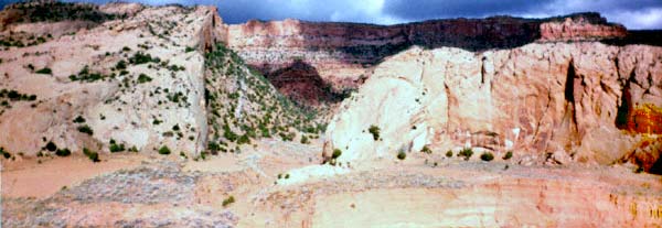
Near the north end of Black Mesa [Dzi![]() yíjiin], the valley through which the highway passes narrows
drastically as the Shonto Plateau rises to the north. The Organ Rock monocline lies
north of the highway and tilts the Navajo Sandstone layers that lie well
beneath Black Mesa [Dzi
yíjiin], the valley through which the highway passes narrows
drastically as the Shonto Plateau rises to the north. The Organ Rock monocline lies
north of the highway and tilts the Navajo Sandstone layers that lie well
beneath Black Mesa [Dzi![]() yíjiin]
sharply up and exposes them as the Shonto Plateau and Skeleton Mesa [Tsin Kíikaad].
yíjiin]
sharply up and exposes them as the Shonto Plateau and Skeleton Mesa [Tsin Kíikaad].
Where Tségyi' Canyon cuts through, even older layers are exposed.
The Navajo Sandstone has steep, sweeping cross-beds with fine, even grains of sand, typical of
rock formed from sand dunes.
This Navajo Sandstone is the important aquifer for this area. The rain water sinks into
the sandstone on the Shonto Plateau and the narrow area between the plateau and Black
Mesa [Dzi![]() yíjiin]. This area of approximately 100 square miles must supply water to a much larger area,
including the Hopi lands [Kiis'áanii bikéyah]
as well as the Navajo [Diné bikéyah].
The current rate of water withdrawal
exceeds the recharge rate. Much of this water is used by the Peabody Coal Company in
its slurry lines to move the coal it mines from Black Mesa [Dzi
yíjiin]. This area of approximately 100 square miles must supply water to a much larger area,
including the Hopi lands [Kiis'áanii bikéyah]
as well as the Navajo [Diné bikéyah].
The current rate of water withdrawal
exceeds the recharge rate. Much of this water is used by the Peabody Coal Company in
its slurry lines to move the coal it mines from Black Mesa [Dzi![]() yíjiin]. Many local wells are
going dry because of this use.
yíjiin]. Many local wells are
going dry because of this use.

References